Showing posts with label (maps). Show all posts
Showing posts with label (maps). Show all posts
Sunday, October 25, 2009
mapping people densities

mapping out across some of the bike lane streets (pink) some routes that our tourists (yellow) or locals (blue) might take to get around. Also placing some hexagon footprints near the train stations in a variety of capacities as well. Some other ones near where a larger train station one might run out of space or bikes and could overflow to a piazza a few blocks away, which may benefit from having a 2-or-3 configuration on its own anyway.
Also looking into Jan Gehl on Caitlin's recommendation who is responsible for designating streets for pedestrians or cycles or whatnot.

Saturday, October 17, 2009
...Ninjas on the net
Just so I have this handy for the meeting in an hour and a half, I'd mentioned these diagrams that are posted to the site ArchitectureMNP. Every week they post links to interesting stuff in the NOTN posts, but they(him, her?) always sticks a real interesting map or diagram at the top of each.
 All streets in the US.
 'objects orbiting earth'.
 internet connections in europe
 Cartogram showing countries' military spending
Fun stuff to say the least. Check out Ninjas on the Net posts here. There are lots of really interesting things linked in the posts too, though much of it would be only loosely related to what we're working on.
Anyway, i thought some of these might inform our graphic description of the network of bikes throughout danmark. perhaps we could make some approximation of useage and directionality and make a sweet map that could serve as an example of what their traffic analysts and urban planners would see from the incessant stream of RFID and GPS information coming in.
See y'all soon...

 All streets in the US.
 'objects orbiting earth'.
 internet connections in europe
 Cartogram showing countries' military spending
Fun stuff to say the least. Check out Ninjas on the Net posts here. There are lots of really interesting things linked in the posts too, though much of it would be only loosely related to what we're working on.
Anyway, i thought some of these might inform our graphic description of the network of bikes throughout danmark. perhaps we could make some approximation of useage and directionality and make a sweet map that could serve as an example of what their traffic analysts and urban planners would see from the incessant stream of RFID and GPS information coming in.
See y'all soon...
Tuesday, October 6, 2009


Tuesday, September 29, 2009
...some thoughts and a few maps found
So i was perusing the website of what is essentially Copenhagen DOT and I found a few maps that may be useful to us in understanding the nature of traffic in the CBD of the city.

The rest of the maps can be found in PDF here.
Also worth checking out is the Cykelkort (bike map) here (large PDF).

The second page provides potential cyclists with instructions on proper map folding techniques, existing bike-share (city bike) rules, explanations of transportation connections and rules, as well as a small map of the metro system.

Interestingly, It says that the city bikes may not be used after dark and must be returned to an appropriate rack before nightfall or you risk getting an "on the spot" fine by the police (which judging by the danish cops I've met probably means you'll get a mild warning and then a hug or punny joke so you don't leave feeling disheartened or singled out) because the bikes are not equipped with lights.

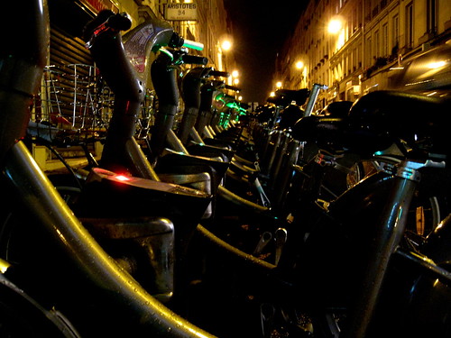
As you can see, the current shareable bikes leave a lot to be desired... I doubt we could win trying to convince the government to shell out the DKK's for everyone to ride on one of these, but at least we could push the integration of an electrical system on every bike so that the 'after hours' rule will no longer apply (don't worry, they don't create asinine laws to generate revenue there like in NYC; so they'll likely welcome the idea).
On that note, the MOOF bike I saw at ICFF earlier this year is a good example of what I'm getting at:

There's a generator in the rear hub that powers the lights while the bike is in motion ( and afterward for some time too, I think). I suggest we shy away from the exaggerated top tube, but otherwise I would think a bike of this stature would be a great jump-off point for the bikedesign aspect of the competition.... durable, chainguard, fenders, etc...
Anyway, I'm going to attempt to assemble those road-use maps and print it out large for tomorrow as well as procure a big street map for identifying key transport hubs and intersections.
Lastly, I thought of a danish to english pun while writing this that could perhaps be incorporated into the branding: ByCykel (looks like "bicycle" in english, but reads as "town bicycle" in danish)
zing!

The rest of the maps can be found in PDF here.
Also worth checking out is the Cykelkort (bike map) here (large PDF).

The second page provides potential cyclists with instructions on proper map folding techniques, existing bike-share (city bike) rules, explanations of transportation connections and rules, as well as a small map of the metro system.

Interestingly, It says that the city bikes may not be used after dark and must be returned to an appropriate rack before nightfall or you risk getting an "on the spot" fine by the police (which judging by the danish cops I've met probably means you'll get a mild warning and then a hug or punny joke so you don't leave feeling disheartened or singled out) because the bikes are not equipped with lights.

As you can see, the current shareable bikes leave a lot to be desired... I doubt we could win trying to convince the government to shell out the DKK's for everyone to ride on one of these, but at least we could push the integration of an electrical system on every bike so that the 'after hours' rule will no longer apply (don't worry, they don't create asinine laws to generate revenue there like in NYC; so they'll likely welcome the idea).

On that note, the MOOF bike I saw at ICFF earlier this year is a good example of what I'm getting at:
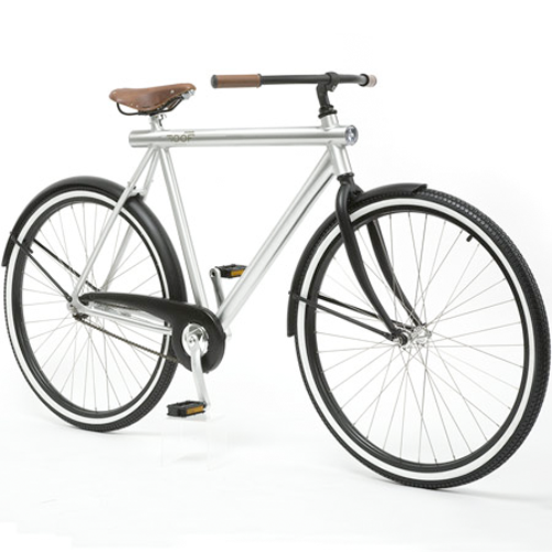
There's a generator in the rear hub that powers the lights while the bike is in motion ( and afterward for some time too, I think). I suggest we shy away from the exaggerated top tube, but otherwise I would think a bike of this stature would be a great jump-off point for the bikedesign aspect of the competition.... durable, chainguard, fenders, etc...
Anyway, I'm going to attempt to assemble those road-use maps and print it out large for tomorrow as well as procure a big street map for identifying key transport hubs and intersections.
Lastly, I thought of a danish to english pun while writing this that could perhaps be incorporated into the branding: ByCykel (looks like "bicycle" in english, but reads as "town bicycle" in danish)
zing!
Sunday, September 27, 2009
this is GIS
this is GIS
more info: wiki
the following images are from http://www.openstreetmap.org/ [this is an open source website, so the information may not be reliable and accurate, but it's a good base for orientation. there is an option to download GIS xml layers - these files are quite large so i'm going to work on downloading them for our use.]


the following transit maps were found online:


my hope in obtaining this basemap data and transit data in GIS [and possible a data layer of the existing bicycle tracks/lanes] is so we can customize the maps to what we want to represent in our proposal at a high resolution for reproduction. if i am unable to find the GIS data, we can most likely superimpose and edit these maps, which were most likely generated with GIS, for our use [we just have to be sure to cite the source].
some additional maps:
bicycle track map:
source: http://maps.grida.no/go/graphic/copenhagen-paradise-for-cyclists1

proposed 'highway' bike map:
via Copenhagenize

neighborhood map:

more info: wiki
the following images are from http://www.openstreetmap.org/ [this is an open source website, so the information may not be reliable and accurate, but it's a good base for orientation. there is an option to download GIS xml layers - these files are quite large so i'm going to work on downloading them for our use.]


the following transit maps were found online:


my hope in obtaining this basemap data and transit data in GIS [and possible a data layer of the existing bicycle tracks/lanes] is so we can customize the maps to what we want to represent in our proposal at a high resolution for reproduction. if i am unable to find the GIS data, we can most likely superimpose and edit these maps, which were most likely generated with GIS, for our use [we just have to be sure to cite the source].
some additional maps:
bicycle track map:
source: http://maps.grida.no/go/graphic/copenhagen-paradise-for-cyclists1

proposed 'highway' bike map:
via Copenhagenize

neighborhood map:

Subscribe to:
Posts (Atom)